


-
প্রথম পাতা
-
উপজেলা সম্পর্কে
উপজেলা পরিচিতি
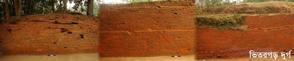
ইতিহাস-ঐতিহ্য
ভৌগলিক ও অর্থনৈতিক
- উপজেলা পরিষদ
-
উপজেলা প্রশাসন
উপজেলা নির্বাহী কর্মকর্তা
সংগঠন সম্পর্কিত
কর্মসূচি ও অন্যান্য
সেবা ও অন্যান্য
সভার কার্যবিবরণী ও অন্যান্য
- পৌরসভা
-
সরকারী অফিস
আইন-শৃঙ্খলা বিষয়ক
স্বাস্থ্য বিষয়ক
কৃষি ও খাদ্য বিষয়ক
ভূমি বিষয়ক
প্রকৌশল ও যোগাযোগ
মানব সম্পদ উন্নয়ন বিষয়ক
-
অন্যান্য প্রতিষ্ঠান
শিক্ষা প্রতিষ্ঠান
- মুজিব বর্ষ-২০২০
-
গ্যালারি
ফটোগ্যালারি
ভিডিও গ্যালারী
২৬-২০ ডিগ্রী উত্তর অক্ষাংশে এবং ৮৮.৩৪ ডিগ্রী পূর্ব দ্রাঘিমাংশে অবস্থিত পঞ্চগড় জেলার ভৌগলিক অবস্থান তাৎপর্যপূর্ণ । ১৯৪৭ সালে স্যার সিরিল রাডক্লিফ কর্তৃক নির্দেশিত এই জেলার সীমান্ত রেখা অত্যন্ত আঁকাবাঁকা ও ভংগুর। পঞ্চগড় জেলার তিন দিকেই ভারতীয় সীমান্ত। পঞ্চগড় জেলার সাথে ভারতীয় সীমান্ত এলাকার দৈর্ঘ্য ২৮৬.৮৭ কিলোমিটার। এ জেলার উত্তরে ভারতের দার্জিলিং ও জলপাইগুঁড়ি জেলা, উত্তর পূর্ব ও পূর্বে জলপাইগুঁড়ি ও কুচবিহার জেলা এবং বাংলাদেশের নীলফামারী জেলা, পশ্চিমে ভারতে পুর্নিয়া ও উত্তর দিনাজপুর এবং দক্ষিণ ও দক্ষিণ পূর্বে বাংলাদেশের ঠাকুরগাঁও ও দিনাজপুর জেলা অবস্থিত।
রেডক্লিভ রোয়েদাদ অনুযায়ী ১৯৪৭ সালে অবিভক্ত দিনাজপুর জেলার ৩০ টি থানার মধ্যে ৯টি সম্পূর্ণ এবং একটি আংশিকভাবে বাংলাদেশের দিনাজপুর জেলার সঙ্গে যুক্ত করা হয়। অবশিষ্ট ২০ থানার মধ্যে পোরসা, পত্নীতলা ও ধামইরহাট থানাকে রাজশাহী জেলার অন্তর্ভূক্ত করা হয়। একই সময় জলপাইগুড়ি জেলার দেবীগঞ্জ, বোদ, তেঁতুলিয়া ও পঞ্চগড় থানাকে কেটে যুক্ত করা হয় দিনাজপুর জেলার সঙ্গে।
স্যার রেডক্লিভ ১৯৪৭ সালে দিনাজপুর জেলার অংশ হিসেবে পঞ্চগড় অঞ্চলে নিম্নরূপ সীমানা নির্ধারণ করেন :
A line shall he drawn along the houndary between the thana of `Phansidewa' in the district of Darjeeling and the thana 'Tetulia' in the district of 'Jalapaiguri' from the point where the boundary meets the province of Bihar and then along the boundary between the thana of 'Tetulia' and Rajgang : The thanas of 'Panchagarh' and 'Rajganj' : and the thana of 'Panchagarh' and 'Jalpaigue' : and shall then Continue along the morthern Corner of hte thana 'Debigang'. to the boundary of the state of 'Cooch Bihar'. The district of Darjeeling and so much of the district of the district of Jalpaiguri as lies north of this line shall belong to west Bengal. উল্লিখিত বঙ্গানুবাদ মোটামুটি এরকম- বিহার প্রদেশের সীমানা যেস্থানে দার্জিলিং ও জলপাইগুড়ি জেলার সীমানা স্পর্শ করেছে, সেখান থেকে একটি রেখা দার্জিলিং জেলার ফাসিদেওয়া থানা এবং জলপাইগুড়ি জেলার তেঁতুলিয়া থানার মধ্য দিয়ে টানা যেতে পারে। এরপর রেখাটি তেঁতুলিয়া ও রাজগঞ্জ থানার মধ্য দিয়ে এবং পঞ্চগড় ও রাজগঞ্জ থানা, অতঃপর পঞ্চগড় এবং জলপাইগুড়ি থানার মধ্য দিয়ে অগ্রসর হয়, দেবীগঞ্জ থানার উত্তর কোণকে স্পর্শ করে কোচবিহার রাজ্যের সীমানা পর্যন্ত সম্প্রসারিত করা যেতে পারে। দার্জিলিং ও জলপাইগুড়ি জেলা দুটি এই রেখার উত্তর প্রান্তে অবস্থান করতে এবং তা হবে ভারতীয় ভূখন্ডের অন্তর্ভূক্ত।
রেডক্লিভ মিশন কর্তৃক পঞ্চগড় থানার সীমানা নির্দেশ করতে গিয়ে জলপাইগুড়ি জেলার ১২ নং বেরুবাড়ি ইউনিয়ন কেন্দ্র করে সৃষ্টি হয় জটিলতা। সে সময় সমস্ত ইউনিয়নকে তৎকালীন পাকিস্তানভূক্তির দাবী উঠেছিলো। কিন্তু কার্যত তা বাস্তবায়ন হয়নি। এই অমিমাংশিত বিষয় দু’দুইবার রাষ্ট্রীয় শীর্ষ পর্যায়ে চুক্তি দ্বারা নির্দেশিত হয়: প্রথমত “নেহেরুনুন চুক্তি” স্বাক্ষরিত হয় ১৯৫৮ সালের সেপ্টেম্বর মাসে, দ্বিতীয়ত “মুজিব-ইন্দিরা চুক্তি” স্বাক্ষরিত হয় ১৬ই মে ১৯৭৪ সালে।
নেহেরুনুন চুক্তির বিবরণ- ১৯৫৮
This will be os divided as to give half of the area of Pakistan the other half adjecent to India being retained by india. The division of Berubary Union-12 will be horizontal, starting from the north-east corner of Debigang thana. The division should be made in such a manner that the kooch-Bihar enclaves between Panchagur thana of East Paikstan and Berubarie Gnion No-12 of Jolpaiguri Thana of West Bengal will remain connected as at Present with Indian territory and will remain with india. The 'Kooch Bihar' enclaves lower down between boda Thana and Berubari Union 12 will be exchanged along with the general exchange of enclaves and will go to pakistan.3
মুজিব-ইন্দিরা চুক্তির বিবরণ-১৯৭৪
Indiawill retain the southern half of south Berubari Union 12 and the adjecent enclaves, measuring an area of 2.64 sq. miles approximately, and in exchange Bangladesh will retain the `Dahagram' and `Angorpota' enclaves. India will lease in Perpetuity to Banlgadesh an area of 178m. X 85m. near 'Tin Bigha' to connect 'Dahagram with 'Panbari' mouza (p.s Patgram) of Bangladesh.


পরিকল্পনা ও বাস্তবায়নে: মন্ত্রিপরিষদ বিভাগ, এটুআই, বিসিসি, ডিওআইসিটি ও বেসিস
কারিগরি সহায়তায়:
![]()
সফটওয়্যার তৈরি:
